

The Future of Earth Observation, Part II
Earth observation satellites do not come cheap. As mentioned in the previous post of this series, until a few years ago, they could cost a few hundred million dollars a piece to build and launch. This makes satellite observation expensive, even for organisations that only buy the images. However, the end users are willing to spend that kind of money – 1.6B$ for commercial Earth Observation in 2014- because satellite imagery is the best way to address some specific needs. The aim of this post is list those needs, and explore what characteristics of satellite imagery are required to serve them.
Reliable intelligence
The historical use case of satellite imagery has been to gather extensive and objective intelligence on foreign countries. This has been the goal of the US reconnaissance program from the start of the Cold War, with a focus on China and the USSR. Satellites even became the only means to collect imagery deep inside the USSR after an U-2 reconnaissance plane was downed over the Soviet Union in 1960. Of course, imagery is not all. Intelligence can still be collected from human sources, using more traditional methods. But human intelligence has reliability issues: if no source can be found at the right place at the right time, then it is blind. If a source can be found nevertheless, it is not always a trustworthy one; history of full of double agents or outright liars who invent information.
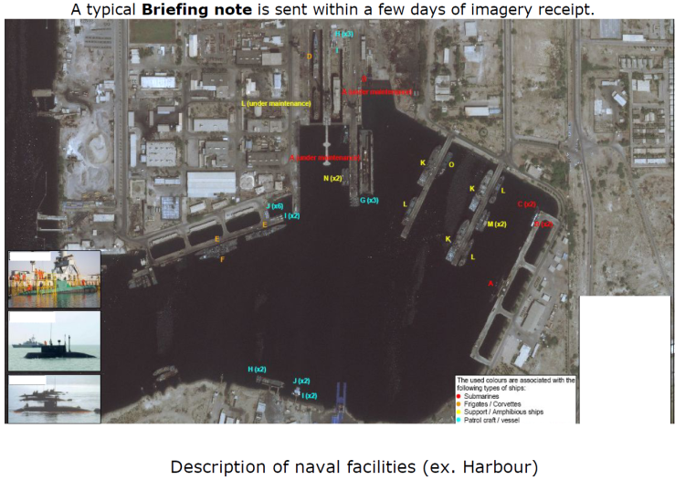
Satellites, on the other hand, are cold and repeatable machines: they may not see everything, but they can see everywhere, and they do not produce fake images to further an agenda. As a result, they can provide objective, actionable intelligence: with its spy satellites, the USA could assess the military capabilities of the USSR, and especially the size of its armies. The images themselves are however only the starting point of an intelligence process: they are usually first turned into a briefing note by an analyst, then the information moves up the interpretation chain often by being correlated with other sources of information, and finally the finished intelligence product is distributed to decision makers.
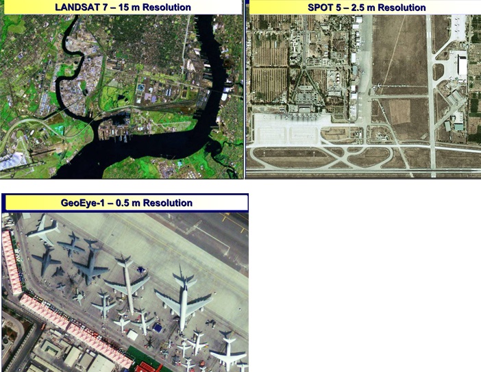
In order to achieve this, high resolution imagery is necessary, to be able to precisely detect, identify and characterize objects such as planes, radars and ships. This means 1 pixel of the image has to correspond to a small distance on the ground, typically 1m of less, but smaller is better. Higher resolution enables to perform more challenging tasks, such as distinguishing between similar plane models, or estima. The US National Image Interpretability Rating Scale (NIIRS, available here) lists such tasks and the minimum resolution required.
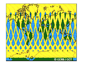
A wide coverage can also be useful: the ability to collect images of most of the surface of a country, and not only a few places, reduces the chances of missing important information. This increases the confidence in the final intelligence product.
Finally, a high revisit -having images of the same site every day for instance- makes it possible to catch transient events, and makes it harder to hide activity from the satellite. It also makes the interpretation of the activity easier.
Crisis management
Timely satellite imagery can be a powerful tool for crisis management. It can help track the progress of forest fires, assess the extent of floods and landslides, and evaluate the impact of industrial accidents. It can have military applications too, by detecting ships, ground troops, or airport activity, and assessing the impact caused by air strikes.
The key aspect in all these applications is latency: images have to be delivered quickly to the end-user once they have been acquired, or otherwise the information they contain will be outdated. Latency also has an impact on satellite tasking: the time between when an user makes an image request and when the request is uploaded to the satellite has to be low, or else the satellite can miss imaging opportunities.
Revisit is also important for crisis management: a short time between revisits means more imaging opportunities, and a more regular flow of information to the end-user. A single satellite can provide images of a given location every few days, but a constellation can give images every day, or even several times a day.
Resolution is needed for some tasks. For floods and landslides, the affected areas can be seen in low-resolution images, but for military or industrial assessments, high-resolution images are necessary.
Finally, georeferencing accuracy, that is, the ability to extract the exact GPS coordinates of a pixel in the image, is especially critical for military planning.
Agriculture and Mining
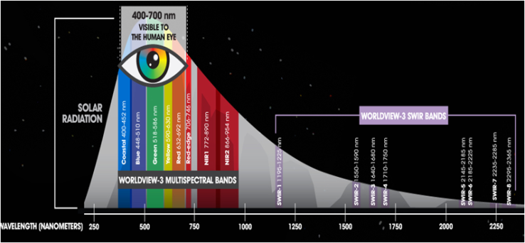
Satellite are also very useful to perform resource survey for crops or minerals. These applications mostly require a wide coverage, but not a high spatial resolution. However, they benefit from a high spectral resolution: different minerals in the ground give slightly different colours, which can be detected by a sensor able to finely distinguish between light wavelength. Such a sensor is called a multispectral sensor. Whereas standard sensors typically capture only red, green and blue channels, a multispectral sensor can capture much more colours, starting from the near infrared (to detect crops), and extending in the thermal infrared.
Mapping
Mapping used to require long ground surveys or more recently, aerial surveys. Now part of the job can be accomplished by satellites. It is another area where coverage is key, along with accurate georeferencing: with an accurate 3D location of all points of the image, a digital elevation model can be build, which can help infrastructure planning, or low-altitude flight planning .
Economic monitoring
Economic monitoring is a civilian version of the intelligence use case, with the goal to objectively and frequently measure the economic activity of a region. It includes applications such as monitoring oil reserves (by measuring the volume of oil tanks) or store attendance (by counting cars in parking lots)
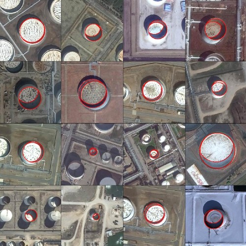
To capture quickly-evolving event such as these, a moderate resolution (~1m) and a very high revisit rate are needed, because store attendance for instance depends a lot on the time of day.

[…] This post is a part of a series on the future of earth observation, and is a follow up to The Future of Optical Earth Observation I: The road so far and The Future of Earth Observation II: What do users really want, anyway? […]
LikeLike